
TL;DR
How to assign a score, systematically to datasets for autonomous driving.
Summary
The outcome of this work is a description of the data readiness levels (DRLs) in the ROADVIEW project. Essentially DRLs are the data ‘equivalent’ of Technical Readiness Levels (TRLs). Specific is included in the title means internally generated and externally available datasets for autonomous driving. As well as the datasets we introduce the concept of data readiness levels and how the levels are implemented. DRLs are a general concept for differing data kinds, that said, we will use our own collated metrics for the specifics related to autonomous driving initially.
Data quality detractors are not solely sensor related, non-domain aspects, missing data, corrupted values, processing errors are generic problems in data processing and can lead to insufficient HD map quality and therein can miss important objects in the test drives. We do not provide a DRL value for the datasets in this work, as LiDAR and RADAR data has not been evaluated in sufficient detail, but we provide a roadmap for LiDAR evaluation. Clearly, data for autonomous driving is an enormous area crossing many disciplines, vision, ML, metrological, measurement techniques, sensing, instrumentation, and we do not attempt to cover all these topics however provide a slice through the topic with an example of image quality.
Objectives
The main objective of this page is a report on how to quantitatively evaluate the Data Readiness Levels (DRL) of datasets. With the help of this work, we aim to assign a score, 1 (low) to 9 (high) of a specific dataset we have available to us. Datasets can be ROADVIEW partner produced (page 20) or openly available ones (page 24). The final project goal is the ability to upload a dataset and an evaluation thereof of that data for autonomous driving.
Methodology and implementation
The main methodology followed is to define a simple, working assessment of the datasets used in ROADVIEW. Irrespective of the algorithms’ performance (F-Scores, Confusion matrices and so on) the success of autonomous vehicles will largely depend on the quality of data used. Therefore, the data should be of sufficient quality for the scenarios and settings defined in the project. Since the goal of the project is to enable autonomous vehicles to operate in rain and snow, the coverage, quality, and settings will be a determining factor in the projects’ success. Also, quantitively, where the operation of the vehicle perception is too low, we can pinpoint at least where the data is/was insufficient using the main concept. Backtracing from an object misclassification (or missing at all) to the HD MAP, data source (Visible camera, Infra-red, LiDAR, RADAR) to the pixels and potentially a sensor issue would be a truly valuable tool in this field, akin to a debugger in software development.
Outcome
The outcome of this first work on this topic is an overview of the domain of road sensor fused simple. It is more of an informational type of work, however, with concrete examples from internal and external datasets.
Part I: Preliminaries
What’s in this text?
Essentially this work contains an evaluation of internally produced and publicly available datasets for autonomous driving. An emphasis is on scenes with poorer driving conditions. How driving conditions impacts on sensor performance and subsequent data flows is also addressed. An end-to-end software example is used as an illustration. VISIBLE and thermal cameras are considered, RADAR and ultrasonic sensors less so.
What’s not in this text?
Some issues are not included in this work, on is sensor calibration, cameras and LiDARs (though LiDAR calibration can be found in this Link). This is mostly due to the competence area, as well as access to specialised equipment. We will also not discuss issues in ROADVIEW available in other Work packages and work however are related to datasets. Examples include ODDs (WP2, Task 2.1) and the Data Management Plan but (WP1, T1.4) refer to other work packages and tasks within ROADVIEW. RADAR data is not discussed in detail this work, again due to competence in this task and data at a timely point. It will be covered in future dataset evaluation.
Data in ROADVIEW: a perspective
Introduction
In this work on data quality, we split the initial data readiness into 2 sections:
- Introduce data readiness concepts.
- The data details about the data set(s) for assessment.
Figure 1 – Data plays a central role in the many projects. Above, is a generic view of data of the data processing stages. The lower DRLs are processed bottom first. A specific DRL illustration is in Fig. 8.
The big (data) picture
We look at the increasing role of data in computer-based tasks. Taking a step back computer science works on some simple principles. Although many computer scientists developed these, the idea of splitting the thinking process into Data and Control was coined by Alfred Aho (still lectures at 82 years old at Columbia University) of AWK fame). These are shown below. Looking back, the amount of data processed was much less than now and the focus was on controlling the program to achieve complex tasks. Data was typically input -> processed -> output.
Programs = Control + Data
As key algorithms (many formalised and popularised by Knuth) development of the algorithms, especially their complexity became key. Control flow became algorithms, which can be used again and again in different contexts. Again, the separation of the data and the algorithms is a key philosophy. Many systems and programs today could benefit from working code to a specific (well known) algorithm that can be changed or improved. Searching and sorting being the classics.
Application = Algorithms + Data
Jumping forward a few decades in computer science, a key change has been the use of large amounts of data. This jump in huge data amounts is not only related to Machine Learning and AI, but gathering data from our environment, roads, earth observations, Internet logs, nuclear particles and so on. Whence scanning, capturing, measuring our environment (at whatever timescale or physical dimensions) data has become pervasive. In autonomous driving, sensing, gathering, processing, validating, (even legalising) data is so important, it is almost the most important facet of a project such as ROADVIEW. We do not demean the algorithms or computer science; however, the roll of data is of uppermost attention in projects such as ROADVIEW. It is logical that the quality of the data, should be and is an important part of the project.
Autonomous driving = Algorithms + Training Data + Testing Data + Testing
Therefore, ROADVIEW will (i) introduce a novel concept of sensor denoising to filter out noisy sensor readings (camera, LiDAR, and RADAR) and (ii) assign a data readiness level to validate the quality of the raw data before passing them to the perception modules. This will lead to more robust perception under varying environments and weather conditions. In terms of assessment, we need to stipulate that in image and video quality for ML processing (pipelines) introduces new and different issues when quality assessment is for people. This we will come back to when discussing the VISIBLE image and video quality.
The ROADVIEW reference architecture The work in this task is in essence adjunct to the architecture work done in the Architecture Reference Task, part of WP2. Figure 2 below shows the generic architecture ROADVIEW uses. It represents the core functional generic architecture of the ROADVIEW project. Novel ROADVIEW modules are shown in dark grey, and available OEM modules in light grey colours, respectively. There are 3 functionalities: Perception, Planning, and Control in red, purple, & blue. The perception block functions are for robust environment perception. Basically, filtering of noisy sensor data, low-level sensor fusion, object detection, free-space detection, weather-type detection, slipperiness detection, and visibility detection. The perception block receives input from various sensing modalities such as RGB cameras, LiDARs, RADARs, Thermal cameras, Inertial Measurement Units (IMU), and Global Navigation Satellite System (GNSS) modules. The planning block is for localisation, trajectory prediction & planning functionalities. The controller block focuses on weather-aware decision-making and control of the velocity and acceleration-related parameters. Each sensor reading is processed individually up to the low-level sensor fusion module, which feeds the downstream perception modules such as object detection. Dashed arrows in the figure represented sensor readings cleaned from noise (i.e., outliers) introduced by, for instance, falling snow particles or rain drops.
The reference architecture in Figure 2 drives our Readiness Level development. Table 3 shows the DRLs, and the sensor calibration and synchronisation above correspond to level 0 in our DRLs. That is before data is gathered, and per modality, the calibration needs to be done. We mean extrinsic calibration with respect to calibration in this case. Data filtering maps to data quality assessment in our DRL schema, that is levels 2-7. These are described in more detail below with an example. We do not look at the quality of the fused modalities in DRL in this first report, rather per modality.
The project methodology with respect to data is to find the best from each dataset and as a final dataset release a ROADVIEW dataset. Indeed, one of the objectives of ROADVIEW is ‘stamp’ the dataset with a quality value from 1 (lowest) to 9 (highest). We need to state here, the value attributed to a dataset, or indeed amalgamation should not be used to compare datasets at this stage. That is because the setup, calibrations, vehicles, conditions will not be the same from dataset to dataset. However, we will look at being able to provide DRL scores per configuration, in the latter parts of this Task. There are no specific datasets required to assess the quality, nor specific modalities. Should there be more than 1 device type we will initially average over the values, and if a modality is missing, their contributions or weights are simply reassigned to the existing modalities.
Data sources in autonomous driving
From a dataset point of view the simplest view of the project is:
Data in ROADVIEW project = VISIBLE Camera data +
Thermal Cameras +
LiDAR data +
RADAR data +
IMU sensor positioning data +
GNSS data
To be clear, the project is large, complex and has many facets, weather modelling, testing, system integration, testing and finally working demonstrations using real trucks. That said, a vehicle that uses sensors to navigate, avoid and find its destination with respect to the road and weather conditions will be make heavy use of data, especially in the training phase. That is where the test vehicle performs journeys (see below) to learn of all possible situations it will encounter when licensed and driving passengers around. The goal from autonomous driving is to produce a “picture” of the environment, often called an HD map. In ROADVIEW this is discussed in additional detail in Tasks T5.4 and T8.3.
Part II: Sensors and data
Brief overview of the sensor types in the ROADVIEW project
To design and operate a vehicle in harsh weather environments, a number of sensors, platforms and processing is needed. Below we give a high-level overview, mostly for the laymen. A complete system requirement has been produced in WP2, the preparation of the demonstrators, a complete list can be found in WP2 system requirements document. Table 1 below gives a general overview of the sensor types and some characteristics.
Table 1 – Simple summary of sensors in autonomous driving
(source: An Overview of Autonomous Vehicles Sensors and Their Vulnerability to Weather Conditions. Sensor [28])
VISIBLE CAMERAS
Obviously, a key component in vehicle autonomy. Most cameras can be classified as visible or infrared (IR). VIS cameras such as monocular vision and stereo vision capture wavelengths that ranges from 400 to 780 nm, similar to human vision. They are mostly used due to their low cost, high resolution, and their capability to differentiate between colours. Combining two visible cameras with a predetermined focal distance allows stereo vision to be performed; hence, a 3D representation of the scene around the vehicle is possible. However, even in a stereoscopic vision camera system, the estimated depth accuracies are lower than the ones obtained from active range finders such as RADARs and LiDARs. Figure 3 shows two visible light cameras used in ROADVIEW Sekonix SF3324 and the Entron F008A030RM0A, images of the two, with specifications, are in the screenshots below.
Figure 3 – Two visible light cameras used in the ROADVIEW project
THERMAL CAMARAS
Thermal cameras, also known as infrared (IR) cameras, detect infrared radiation, which is essentially heat that objects emit. This makes them different from typical cameras used in autonomous driving systems, which capture visible light. Thermal cameras can offer advantages over normal cameras in night vision, adverse weather, enhanced object detection, reduced false positives and improved braking, detecting living objects rather than non-living. ROADVIEW has access to an Adasky LW Infra-Red Vıper camera. A white paper about thermal cameras and the product is at link.
RADARS
Specifications: RADARs use radio waves in the 5-130GhZ range. RADAR is often classified into short range (~30m) and long range (>150m). The short radars use the 24 GHz ISM band from 24.0 to 24.25 GHz with a bandwidth of 250 MHz, also called as the narrowband (NB). Long-range radars (LRR) use the 77 GHz band, 76-81GHz, to provide better accuracy and resolution in a smaller package. Long range applications need directive antennas that provide a higher resolution within a more limited scanning range.
They are used for measuring the distance to, speed of other vehicles and detecting objects within a wider field of view e.g., for cross traffic alert systems. ROADVIEW has access to a Continental ARS 408-21, data sheet. According to the data sheet the ARS 408-21 and offers anti-collision protection, headway for far-field objects, has non-radar reflecting detection, can classify 120 objects per cluster and has distance and speed monitoring. ROADVIEW also has access to ZF’s Pro Wave, with up to 350 m detection range, and 192 channels at 77 GHz. Figure 4, again, shows screenshots with illustrations and specifications.
Figure 4 – Two RADAR modules used in the ROADVIEW project
LIDARs
For the uninitiated, LiDAR devices use scanning lasers (invisible light @ 330ThZ, 1550 nm) to detect objects from a close distance to several hundred meters away, some in a 360-degree field of view. The units need to reliable for the harsh conditions of the road, rain, dust, and variable lighting, vibration, pollution and so on. They can produce a point-cloud ‘image’ of the scene around the vehicle. Often several are positioned to cover all areas around the vehicle. They generate a lot of information 5630 Kbytes per min (see Table 1 below), this can be lessened by using lower frame rates. In harsh weather the laser beams can become scattered or attenuated. FGI has access to the Velodyne VLS-128, released in 2017, link. It has 360 horizontal view (in the horizontal plane) and 40 degrees vertical. The range is 245 meters and has 0.11 minimum degrees angular. It generates 4.8 million points per second. Carissma has access to i) InnovizOne, released in 2023, has 0.1×0.1 angular resolution, 10 or 15 frame rate, 1 to 250 detection range, 115×24 degree field of view and is ISO 26262 compliant, ii) an Ouster OS1, with a 90–200-meter range, 45-degree vertical field of view, 128 channels and 5.2 million points per second. Figure 5 shows the 2 Velodyne sensors.
Figure 5 – Two LiDAR modules used in the ROADVIEW project
Ultrasound
Ultrasonic sensors are used for close distance obstacle recognition such as parking assistance. The reach of the sensors is typically limited to 50cm, and they are not giving you any obstacle information than the distance. And even given that, they are not as accurate as the other sensors. Pricewise, ultrasonic sensors are very low cost and in nearly every car today as parking assistance. Due to not getting any obstacle information from the ultrasonic sensor, it is not possible to classify an obstacle. Therefore, ultrasonic sensors are not taken into consideration in ROADVIEW. Credit for this information goes to Joachim Glass at Konrad-Technologies (KO).
Internal Measurement Units (IMU)
Figure 6 – An IMU unit
The Inertial Measurement Unit or IMU consists of two sensors: An accelerometer and gyroscope. The accelerometer measures the linear acceleration whereas the gyroscope measures the angular velocity. With a known starting location and precise acceleration measurements, the IMU provides information on current vehicle location and orientation. The IMU is the only sensor technology that is independent of any information from the visual or radio spectrum. The performance of IMU is limited only by the accuracy of acceleration measurements of the sensor itself. Unlike sensors such as cameras and LiDAR’s, an IMU can be installed to a shielded container, deep into the vehicle’s chassis. ROADVIEW has access to several IMUs. Figure 6 shows an IMU used by Sensible4, Finland.
GNSS
GNSS is the most widely used technology for providing accurate position information on the surface of the earth. The best-known GNSS system is the Global Positioning System (GPS), which is a U.S. owned utility that provides users with positioning, navigation, and timing (PNT) services. The operating principal the ability of the receiver to locate at least four satellites, calculate the distance to each & identify the receiver location using trilateration. GNSS signals suffer from several errors that degrade the accuracy, such as: (1) timing errors due to differences between the satellite atomic clock and the receiver quartz clock, (2) signal delays due to propagating through the ionosphere and troposphere, (3) multipath effect, and (4) satellite orbit uncertainties. To improve the accuracy of current positioning systems on vehicles, data from satellites are merged with data from other vehicle sensors to achieve reliable position information. In the ROADVIEW project we use Novatel Span-IGM-A1 and the XSenseMTI-710-2A8G4 GNSS sensors.
Sensor
Used in / Required for ROADVIEW Innovation
Parameter
ROADVIEW minimum sensor requirement
RGB Camera
Data Filtering
Low-Level Sensor Fusion
Object Detection
Free Space Detection
Weather-Type Estimation
Slipperiness Estimation
Visibility Estimation
Number of Sensors
3
Field of View
TBD
Resolution
2MP
Framerate (Hz)
10Hz
Sensor Model
RGB Camera
Placement
Front, (Rear optional), both Sides
LiDAR
Data Filtering
Low-Level Sensor Fusion
Object Detection
Free Space Detection
Weather-Type Estimation
Slipperiness Estimation
Visibility Estimation
HD Mapping
Localization with HD Mapping
Number of Sensors
1
Field of View
360° horizontal
40° vertical
Resolution
128 bin
Framerate (Hz)
10
Measurement Range (m)
80
Sensor Model
No Requirement
Placement
Top
(to minimize obstacles)
RADAR
Data Filtering
Low-Level Sensor Fusion
Object Detection
Free Space Detection
Weather-Type Estimation
Visibility Estimation
Number of Sensors
= 1
Field of View
TBD
Resolution
TBD
Framerate (Hz)
= 10
Measurement Range (m)
= 100
Sensor Model
No Requirement
Placement
Front
Thermal Camera
Low-Level Sensor Fusion
Object Detection
Free Space Detection
Weather-Type Estimation
Slipperiness Estimation
Number of Sensors
= 1
Field of View
TBD
Resolution
TBD
Framerate (Hz)
= 10
Sensor Model
No Requirement
Placement
Front
GNSS
HD Mapping
Localization with HD Mapping
Number of Sensors
1
Framerate (Hz)
= 10
Sensor Model
No Requirement
Placement
Antenna on Top
IMU
HD Mapping
Localization with HD Mapping
Number of Sensors
1
Framerate (Hz)
= 100
Sensor Model
No Requirement
Placement
No Requirement
Table 2 – Minimum requirements on ROADVIEW sensor set, being defined in Task 4.1. The Data Readiness Level will be dependent on the setup, this is one example of what a setup will be.
HD Mapping
An HD (High Definition) map is a detailed and highly accurate digital representation of the real-world environment, primarily developed for autonomous driving systems. These maps go beyond the traditional navigation maps that we use in our smartphones or cars. Here’s what distinguishes HD maps from standard maps:
- Detail and Precision: HD maps provide centimetre-level precision, enabling self-driving cars to understand their surroundings better and make informed decisions.
- Layers: Unlike standard maps that might only provide roads and points of interest, HD maps come with multiple layers of information, including:
- Road Profile: This includes details like road curvature, gradient, and width.
- Lane Information: It offers specifics about each lane, its boundaries, type (e.g., turning lane, straight lane), and associated rules.
- Traffic Signs & Signals: HD maps will have exact positions of all traffic signs, signals, and other regulatory markers.
- Infrastructure Details: This may include crosswalks, barriers, guardrails, pedestrian areas, and more.
Dynamic Updates: Given the rapidly changing nature of roads due to construction, accidents, or other events, it’s crucial for HD maps to be frequently and dynamically updated. Some systems aim to update in near real-time. 3D Representation: While many standard maps offer 3D views for a better user experience, HD maps can provide a true 3D representation, accounting for elevation changes and including structures like bridges, tunnels, and buildings. Sensors & Integration: HD maps are typically developed considering the suite of sensors (like LIDAR, radar, cameras) on autonomous vehicles. The data from these sensors can be cross-referenced with HD maps for tasks such as precise localisation. HD maps play a crucial role in making autonomous driving safer and more reliable. By giving vehicles, a comprehensive understanding of their environment, they help ensure that the vehicle can handle complex driving scenarios even if sensors face temporary obstructions or difficulties.
A ROADVIEW data pipeline
Requirements (WP2) ==> Sensor capture (WP4) ==> Format wrangling (WP4) ==> Validation checks (WP4) ==> Fused data (WP4) ==> Model training (WP5) ==> Object detection (WP5)
Data readiness, or quality can be defined for the online or offline case. In the online case could be a situation that was not anticipated or not seen before causing the vehicle to make a poor decision (the classic Über vehicle crash in the US, unfortunately killing a pedestrian). The offline case is pertinent to highlighting of internal practices, where the software system can be “debugged” from a data point of view. Should object detection fail we can look at the causes due to data issues. Note, the algorithms themselves could be issue. These should be tested on a ‘perfect dataset’ possibly machine generated (see below).
Data quality & autonomous vehicles: a short (& selected) state of the art
Since autonomous vehicles are essentially ‘computers on wheels’ data gathering, processing & navigating there is a substantial amount of material. Often citating each sensor type, and increasingly more often, fused data. The photometric society of America produced a paper at the link about Geometric Inter-Swath Accuracy and Quality of LiDAR Data, which is not related to driving but an interesting take on LiDAR data quality. Data quality issues can be found in [1-3]. Within the consortium [4-6] cover vehicle segmentation in LiDAR point clouds. Adverse weather autonomous driving is in [7-13]. Each public datasets have its own set of publications, where nuScenes and mmDetection3D attempt to summarise the others, NuScences ‘corruptions’ a method is close to our work [20]. Around ML pipelines references [15-18] are relevant, where we point to [15] as a lightweight approach. [14] is video quality estimation done by video quality experts, rather than vehicle developers or ML specialists.
Data quality for autonomous vehicles: image quality
A key aspect in this project is the use of multiple sensors in adverse or poor weather conditions. It is anticipated that driving in conditions with non-differentiating backgrounds, water particles in the air (attenuating sensors) make it more difficult for the vehicle to assess surrounding obstacles and obstructions. Visible image quality issues come from lack of sharpness due to focus or dirty sensors, blurriness from lack of focus, confusing ranges and even the speed of the measurement vehicle itself. Obviously over exposed images from bright or low sun / lights as well as reflectance from piles of snow (see citations). If video processing is done on a sequence of images, then single frame ‘images’ can be factor especially over several ones, also due to compression of both images and video. Some form of downscaling is needed, either in frame rates or redundant coding. Below in Table 2 are a couple of image quality assessment tools. Future work will experiment with additional image assessment.
Image
Attribute
Source
Lang.
Comment
GitHub
Stars
Forks
Links / Notes.
Blurriness
Python
Provides a quick & accurate method for scoring blurriness. See Figure 8.
277
1
https://github.com/WillBrennan/BlurDetection2
Multiple
Python
PyTorch Image Quality (PIQ) is a collection of measures and metrics for image quality assessment. The library contains a set of measures and metrics that is continually getting extended
1100
107
https://github.com/photosynthesis-team/piq
Blurriness
Python
Attempts to judge if an image is blurred or not using a score.
–
Own development.
Exposure
Python
No reference image sharpness assessment based on local phase coherence.
40
7
https://github.com/elejke/awesome-defocus-detection
Sharpness1
Python
Sharpness methods.
31
7
https://github.com/topics/image-sharpness
Sharpness2
Python
Sharpness detection
–
Library calculates the
variance of the Laplacian for
each greyscale image.
Brightness
Python
Mean of the pixel values for the greyscale images Over and underexposure
–
Own development.
Noise
Python
Library to calculate
Shannon entropy of each image skimage.
Many and varied.
https://github.com/topics/skimage
LiDAR
Attribute
Source
Lang.
Comment
GitHub
Stars
Forks
Links / Notes.
Point-Cloud Noise
Python
A complete toolbox from Open mmDetection3D.
27.9K
9.2K
https://github.com/open-mmlab/mmdetection Corruption / noise in point clouds. See Figure 18.
Point-Cloud Noise
Python
OpenPCDet is a clear, simple, self-contained open-source project for LiDAR-based 3D object detection.
4.3K
1.2K
https://github.com/open-mmlab/OpenPCDet
Point-Cloud Noise
Python
MultiCorrupt: Weather effects in the point clouds [29].
https://github.com/ika-rwth-aachen/MultiCorrupt
Table 3 – Image & LiDAR quality assessment with open-source repos
Still versus motion quality assessment, the quality assessment for video has some options, ffmpeg, the open-source audio and video codec, probably is the best-known for video, notably in cross platform players such as VLC for decoding (usually) and HandBrake (coding). It also includes three quality metrics:
- Peak Signal-to-Noise Ratio (PSNR), which measures the difference between the original and compressed videos. A higher PSNR generally indicates that the reconstruction is of higher quality.
- Video Multi-Method Assessment Fusion (VMAF) developed by Netflix, VMAF is a perceptual quality metric that considers both human vision system models and machine learning models to provide a more accurate quality score.
- Video Structural Similarity Index (SSIM) is another metric that evaluates the perceptual difference between two videos. A value closer to 1 means the videos are more similar.
We can use ffmpeg as the external tool videos, as it has ffprobe and ffplay as sister tools to play, examine and look at the coding, these tools help when dealing with many files. In the VMAF case, a separate codebase and tool is available. Note, however a reference or “best quality” is needed, to make the comparison. Note others exist [14], as well as separate ones for LiDAR [20, 21]. A no reference video quality paper is in [26]. If videos are recoded, or resized or even format changed (mkv, mp4, mov, wmv) one should use the quality comparison tools above. An interesting, and yet unexplored option is to rate images from good weather conditions. In other words, ideal conditions against poor/harsh/adverse conditions, again in other words again, the reference image is the good weather, and the degraded image is in poor conditions.
Data Readiness Levels: The concept
Data Readiness Levels assessment is a method for characterising data readiness for deployment. The overall data quality builds on Lawrence’s data readiness levels (DRL) concept [2] and is a significant part of project planning and development. It is not by chance that up to 80% of the total project time is spent on pre-processing data, basically following the Pareto principle [1]. The principle states “it takes 20% of the time to do 80% of the work, and 80% of the time to do the remaining 20%”, even simpler stated, “one can do the large parts, but the fiddling consumes a lot of time (and effort)”. The main challenges of constructing meaningful data readiness levels are: i) assigning a single DRL (1–9) to large, complex datasets, often with imperfections [2], such as missing values, inaccuracies, and incomplete readings; ii) different readiness suggests different implications to different users, since data is often context sensitive; iii) some data consumers may have methods to handle imperfections, for example, in the missing data case, methods may, or may not, have been coded to handle missing values. Depending on the upstream capabilities, the DRL may be inaccurate [3,4]; and iv) production of quality sensor datasets (real car readings) are currently available for use. One way to see data readiness is the values 1-9 indicate a quantitative measure of the time / effort / cost to repair / replace produce new values. Lower values are in principle easier to fix than those higher up the scale. Note, if errors in the lower end will propagate through the data pipeline causing issues, and probably harder to detect. This is because transformations (scaling, fusing, ML algorithms etc.) are applied and debugging the ML pipeline is more time consuming. Indeed, WP5 deals with making the ML pipeline as transparent as possible.
Lawrence’s initial concept defines data readiness in three different bands—A (utility), B (validity), and C (accessibility)—depending on the knowledge and understanding of the available data and their usefulness for a given objective. We go back to the 9 levels present in TRLs and use them as below in Table 3.
Figure 7 – Lawrence’s data quality bands
Figure 8 – Illustration of the DRLs for ROADVIEW
Level
Type
Description
Example / Notes
9 (highest)
ML
Successful object recognition in harsh weather in a live driving situation.
A vehicle driving around rural and urban environments.
8
ML
Successful computer object recognition in harsh weather conditions.
An actual vehicle is not involved, rather in a lab, (offline) test. Probably
7
ML
Insufficient / incorrect data for training.
6
Video
Video frames
Quality issues
Video quality experts’ group. VISIBLE and thermal different.
5
Video
Video frame
Missing values
Gaps in frames causes problems.
4
Images
Single image
Brightness, contrast, blurriness
3
Images
Single image
Missing streamed values
Gaps in the data sequence (Missing frames in VisualizePixelwiseFusionImages., FGI)
2
Data
Single
image
Incorrect data
Confusing / wrong information. Fields used in inconsistent manners Data repeated in non-normalised DB schemas.
1 (lowest)
Data
Formatting
Mismatches (decimal separators) points, km / mph
Table 4 – Specific Data Readiness Levels for ROADVIEW. The light-yellow shaded cells indicate Domain specific data issues whilst the light blue cells data agnostic processing.
Data source I: The Finnish Geological Institute (FGI) training data
We take a little deeper dive into a dataset available in the ROADVIEW project. Kindly made available by the Finish Geological Institute, we list some of the attributes of the data made available. The scope of the description is quite high-level formats, visualisation to the lower-level formatting and how to unpack and use the four sensor types. Table 4 shows the sensor, the recorded attribute and format and notes on the data.
FGI sensors, formats, and files
Sensor
Format
Notes
Camera
PNG
Anonymised (Blurred faces and number plates).
Unrestricted license compressed format.
Thermal Camera
TIFF
Raw, unrestricted license format (16 bit)
LiDAR
RG
Binary packed range and reflection data
Road weather
RW
Binary packed road conditions data (see below)
RADAR
Not available from FGI (yet)
Table 5 – Data formats from FGI dataset
One aspect of FGI’s data is the use of binary weather formats, binary structured files. FGI use Python’s:
Struct.unpack_from(format, data, offset)
Function to pull out the file’s data. This we needed to generalise for reading other datasets, in other formats such as ROSBAGs. Waymo uses HDF5 (see below).
Road conditions
In the FGI dataset, the road conditions were categorised as in Table 5. Bool represents Boolean, if available and measured or not.
Attribute
Format
Surface Temperature
Bool
State
Bool
Water
Bool
Grip
Bool
Ice
Bool
Snow
Bool
EN15518 State
Bool
Air Temperature
Bool
RH
Bool
Dew Point
Bool
Frost Point
Bool
Data Warning
Bool
Data Error
Bool
Unit Status
Bool
Error Bits
Bool
Table 6 – Road Weather, conditions & data fields in the FGI Dataset
A master’s thesis on the topic has recently been produced, which includes slipperiness and grip [27].
Urban and rural driving data
The Finish Geospatial Institute (FGI) has produced a data set, shown in 7. It was used to generate the video shown in Figure 7. The whole data set size was about 34 Gigabytes for a 10-minute drive. 8 below shows the data rates and message sizes computed in kB / s and in MB / minute. Content-wise the data is divided into a Rural and Urban drives, 1810 and 3027 in PNG, TIFF images and RW ‘format’ (see above) respectively.
Rural
Sizes
Files
Urban
Sizes
Files
Camera anonymised
2.4G
1810
Camera anonymised
4.7G
3027
LiDAR
913M
1810
LiDAR
1.5G
3027
Thermal camera
6.7G
1810
Thermal camera
39M
3027
Road Weather
21M
1810
Road Weather
39M
3027
Table 7 – Two autonomous driving datasets from FGI (https://www.maanmittauslaitos.fi/en/research)
Figure 9 – Example of FGIs Urban 3 data sources fused, Video link (5fps).
The output of a processed urban dataset is a 250 MB video around 5 minutes long at 10 frames per second. The rural one is 60 MB around 3 minutes also at 10 frames per second. More on rates and sizes in Table 7 above. Note this is without RADAR data and does not say anything about training, validating an AI model. The start frames can also be specified and in the rural case this is offset by 300 ‘frames’ as the capturing started early. Table 7 shows the sizes and times to fuse data (offline) the two datasets. Processing was done on a 2021 MacBook Pro (M1 Max CPU).
Environment
Output video (@ 10 frames / sec)
Fusion Time
Rural
60 MB
30 mins
Urban
250 MB
50 mins
Table 8 – Output characteristics using the FGI dataset above.
In terms of performance issues, Python will produce binary files *.pyc rather than text to make the interpreted code into a binary. For large programs (rather than data) this can speed up execution. For optimising the code, one can use timeit to find functions or sequences that consume time. Alternatives are cProfile and very recently, Scalene from Umass, Amherst, USA (Aug 28th, 2023). Table 9 below gives the breakdown per sensor and how the data streams are reduced by down sampling.
Sensor
Data per message (kB)
Freq.
(Hz)
Data rate (kB/s)
MB/min
Data rate in 5Hz
low sampled data (kB/s)
MB/min
Novatel GNSS + IMU positioning
0,09
205,0
19
1,10
19
1,10
Front colour camera
1399
10,0
13984
819
6993
410
Thermal camera centre
241
60,0
14459
847
1204
71
Thermal camera left
240
60,0
14407
844
1200
70
Thermal camera right
235
60,1
14126
828
1176
69
Vaisala MD30
0,04
40,0
2
0,09
2
0,09
Velodyne VLS128 LiDAR
617
9,1
5630
330
3087
181
SUM
62626
3669
13680
802
Table 9 – Sensor sizes and rates from the FGI dataset.
Figure 10 – Blurriness obtained by taking the variation of the Laplacian of the 3000 images in the FGi’s dataset. Image sizes are scaled to HD. Higher values are less blurry.
As can be noted, thermal cameras have a lot higher data rate than other sensors (60Hz vs 10Hz). Now there is 3.6 GB of raw data per minute. If only the frames which are used to generate the sensor-fused frames at 5Hz are listed, the data rates decrease significantly. Computed is a low sampled example in the two last columns, where only 5 samples per second have been taken from all cameras and the LiDAR. In this low-sampled version one minute of raw data is 802 MB. The project will take different data sets under various weather conditions. Using a low sampled would take a few 100’s GBs, but if full resolution is needed, an estimate is > 1TB.
In the initial readiness assessment, RISE introduced the concept of DRLs. Data plays a fundamental role in the ROADVIEW project, making the completeness, correctness and interoperability of data are utmost important aspects of the data processing pipeline. RISE investigated the multimodal sensors that are used in ROADVIEW, summarizing the physical nature of each sensor, but focusing on camera image quality for the initial DRL definition in D4.5. As shown in Figure 8, from the lower DRL levels, DRL 1 is about the sensors and perturbations therefrom. We know snow, ice, dust, and dirt inhibit signals from the LIDAR and RADAR. This is very much the focus of other tasks, with a slight emphasis on RADAR. Calibration at DRL 2 is an important aspect, calibration, which we separate into 2 types:
Intrinsic calibration
Intrinsic calibration is basically sensor calibration, lens alignment, which can result in distorted / rotated images and point clouds, the resulting matrices contain wrong values with respect to reality, often abbreviated to NAs. The abbreviation can stand for Not Applicable, Not Available or Not Assessed[EE1]. In the case of LiDAR, the laser sweeps should be within a range and intrinsic calibration is done to a known point cloud, physically adjusting the LiDARs. Often RGB cameras are seen as the trusted modality. Intrinsic calibration is only done once, rechecks and calibration are redone if something breaks during trials.
Extrinsic calibration
It is important to position the sensors with respect to each other. In vehicles with sensors, often the RGB camera is seen as the ‘base’ sensor or modality. One reason is that one can infer ‘where’ the camera is on the vehicle using internal and external imaging solutions. Speciality software takes pictures outside of the vehicle and inside the vehicle to calculate the position of the RGB cameras. The Radio Cross Section (RCS) of a target is the equivalent area as seen by a RADAR. It is the fictitious area intercepting that amount of power which, when scattered equally in all directions, produces an echo at the RADAR equal to that from the target.
At DRL 3 we deal with missing data, as when streamed from sensors in real time (even when buffered) gaps in the sequence can occur. Data rates exceed capacity, sensors do not always pick up information, noise in the data overrides the signal and so on. The ratio of signal to noise is a key factor in any sensing situation. Theoretical results and extensive practice and calibration can to some degree predict the performance of a sensor, or modality in autonomous driving. However, in practice, and real driving situations it is more difficult to ascertain the signal and noise ratios. In the dataset from FGI a few values are missing, see Figure 11. Two representations of ‘sequence gaps’ in the FGI dataset. The leftmost by differencing, the rightmost by absolute timestamps below.
Figure 11 – Two representations of ‘sequence gaps’ in the FGI dataset. The leftmost by differencing, the rightmost by absolute timestamps.
At DRL 4 we have the positioning and inertia measurement units. For now, we have them at the same level. This could be for discussion later, but knowing where we are (GNSS) and how the vehicle accelerates, brakes, or vibrates is important in post-processing. Repeated runs along the same route in different conditions produces repeatability but also changing, a limited, but known, number of parameters. Indeed, in ROADVIEW runs are done when the weather has changed. An extension is to create the weather artificially, as done in the THI and Cerema test site in Germany and France.
At DRL 5 we have images and the LIDAR / RADAR. They are different modalities, but in essence are similar in terms of sensing. We look at several different open-source tools to assess them.
At DRL 6 we have the collated ‘data’. That is video and LiDAR scans, processed (frame rates, resolutions) single images combined into videos and LiDAR point clouds, spatially and temporally collated. We look at the video quality as well in this Task, using vmaf (Table 61) which the rest of the project does not do. LiDAR point clouds are heavily discussed in this report. With respect to data quality, we have access to the FGI & THI datasets and are evaluating those, and we can introduce weather effects into public datasets and evaluate them, this is done with tools such as MultiCorrupt [29] and Robo3D.
At DRL 7 we have the processing of the point clouds, removing noise from the point clouds to make object recognition effective, this is being done in other parts of the project.
We have left one DRL 8 free as some processing in the ML pipeline, that can affect the final quality. Research is being done to rasterise point clouds, make the point clouds more sense or using multiple sources to enhance quality. Therefore, we leave DRL 8 for each advancement.
DRL 9 is strictly about the object detection, in free space or in scenes that is coupled to the algorithms themselves. We have implicitly assumed that the algorithms are perfect and only data is a detractor, which is strictly not true. The algorithm and often the algorithm and the data it is trained, validated, and tested upon can have significant impacts on the results in AD. This is why different techniques are evaluated, often on several datasets, and with quite different outcomes. The mmDetection suite tests their algorithms on different datasets showng a fair difference. Therefore, the algorithms themselves need to be considered, and this is being done in WP5.
Figure 12 – Otaniemi. A rural route between Hilantie-Pohjoiseen in southern Finland.
Figure 13 – Time series of blurriness. Left: recording in an urban environment.
Right: recording in rural area / transit.
Linear combinations of sensor inputs
The main fulcrum of this work is how the DRL is calculated. For the moment, it is a linear combination of the inputs from the sensors. Should one be missing, RADAR for example, its contribution is distributed amongst the others. Similarly, so with multiple numbers of the same, for example 4 cameras. For forward and backward sensors, we will (for now) exclusively use the forward ones. Side ones will be given 25% max. However, this is a heuristic value and will be explored further.
It is important to reiterate that the Data Readiness or Quality is really for off-line use, to ensure the data is of sufficient quality. It is assumed that the algorithms are ‘perfect’ which is unreasonable, but there are many algorithms and measures to determine how good the algorithm is. Estimating the data quality known the performance (in %) of algorithms is possible, but over complicates the issue and might place emphasis on the wrong place.
An alternative would be start from the other end and say when the object detection is correct in the training data, then the data is perfect and for each ‘imperfection’ in the image correlate this with the classification success. Or a misclassification is back traced to an image that is not clear enough. There is also the issue of the training and validation sets, how they are selected. In the standard image sets this is done, however in our internal datasets this is being assessed.
DRL = VISIBLE imaging + Thermal imaging + LiDAR imaging + RADAR imaging
Implementing DRLs for ROADVIEW
In the first incarnation we used the FGI implementation, which we first refactored, from plotData_example.py source code with four functions:
def ReadRWImage(filename, out_datas=None, ret_image=False):
def ReadRangeImage(filename, ret_image=False):
def ExpandPixels(image, amount):
def VisualizePixelwiseFusionImages(main_folder, start_index=0, show_fused=False):
Consisting of 479 lines. RISE increased the modularity from the 4 functions to 13 functions, and no. of code lines 601. As well as to understand the code better, reduce repeated code, make hooks for reading other data sources, as well as the DRL functions. The code is available from RISE Git Lab. RISE is looking at ice cloud shared notebooks, for now we will share code at the link above internally and use ROADVIEWs GitHub repository.
Figure 14 – DRLs applied to the images from FGI urban journey (credit: The Finish Geospatial Institute, fgi.fi). Top: Simple RGB image. Mid: thermal camera image projected into the RGB camera image. Bottom: LiDAR point cloud projected into RGB camera image.
Finally, for the FGI dataset, Figure 14 shows one representative frame of the dataset, showing the RGB camera as well as thermal counterpart and LiDAR point cloud data, all projected into the RGB camera image. The RGB camera image was rated with DRL 7 while the thermal camera frame only got up to 4 – 5. This is mainly due to the edges of the thermal camera image, simply caused by the working principle of the sensor itself. These edges do cause issues in the image quality evaluation though, hence less DRL rating. Lastly the LiDAR point cloud is yet to be evaluated since the methodology for point cloud rating is not yet finalized. The projected point cloud into the image plane in the bottom image of Figure 12 leads to the question of rating extrinsic calibration, which needs to be further discussed also. Ongoing work will look at the dataset from THI and VTT which has been received by RISE. Together with HH, the LiDAR point cloud data will be projected into spherical coordinate system to generate image representations for assessment. RISE also plans to apply the DRL concept to at least 1 public dataset.
Figure 8 showed the ROADVIEW reference architecture together with the DRL levels. The data readiness level is based on the perception module. The DRLs follow the data flow as indicated in the DRL architecture to the right. Data processing steps that occur in practice that influence the data quality occur in the DRL data processing pipeline are shown in the right figure. An example is dealing with missing data, that is a fact in real time sensing and importantly can detract from the overall quality, furthermore, affects the steps upstream. Therefore, there is no direct 1-1 mapping from the reference architecture to the Data Readiness Levels but is close (and should be).
With the modalities with the datasets we have, FGI is all minus RADAR and THI is all modalities.
The next steps for Task 4.3:
- Continue working with datasets wrt. THI, VTT
- Incorporate RADAR data from RISE
- Look at missing data impacts from VTT
- Investigate how calibration affects DRLs (upwards)
- Look at rasterising point clouds to images
Main outcomes
Initial data readiness levels with respect to the FGI dataset. Developed a software framework for DRLs and open datasets. Evaluated 5 image and 2 LiDAR point cloud datasets.
Data annotations
Whilst most of this report is about data quality, annotating data is a significant issue. In machine learning, data annotation is the process of labelling data. This labelled data is then used to train supervised learning models. Data annotation is a crucial step in many machine learning projects, especially in projects such as ROADVIEW: vision, scene detection. Obviously, the quality and accuracy of the annotated data affects the performance of the resulting machine learning models. Within ROADVIEW we use:
- Image Annotation: This involves marking various objects within images. Types of image annotations include:
- Bounding boxes: Drawing rectangles around objects of interest.
- Semantic segmentation: Labelling each pixel of an image with a class label.
- Polygonal segmentation: Drawing polygons around objects, especially those with irregular shapes.
- Key point annotation: Marking specific points of interest on objects, often used for pose estimation.
- Named Entity Recognition (NER): Labelling words or sequences of words as specific entities like names, locations, or dates.
- Video Annotation: Labelling objects or actions within video sequences. This can involve bounding boxes over time or tagging entire video clips with action labels.
- Audio Annotation: Marking sections of audio data to label different sounds, words, or other audible events.
The process of data annotation is time-consuming, requires domain expertise and ROADVIEW has a Task for this purpose. An interesting angle is active learning, where a machine learning paradigm where the model itself decides which data points should be annotated furthermore, based on where it predicts the annotation would be most valuable. This can help reduce the amount of manual annotation.
Data source II: ROADVIEW-Carissma
Below is the test track and examples of the CARISSMA outdoor test facilities. There is an acceleration zone of 210m and a dynamic area with a 60m x 70m area. The maximum speed is 100km/h. Different parts of the track are watered with different intensities. The. Images show the watering and measurement instrumentation. Initial data sets with images and point clouds have been produced. The full work will be available in Feb. 2024. Figure 15 shows the test track, ‘artificial’ weather conditions (rain) and a LiDAR point cloud in these conditions.
Figure 15 – Refence Dataset of measured weather characteristics, THI D3.2, WP3
Figure 16 – Reference Dataset of measured weather characteristics, THI D3.2, WP3
The datasets were created to observe the 3 weather conditions rain, clear, and fog different conditions on different sensors. The utilised sensors in this case were VISIBLE Camera (LUCID), FLIR (Thermal) Camera, RADAR (ZF ProWave), and LiDAR (Innoviz One and Ouster OS1). This dataset has a total of 68.4 minutes of recording. The recording took place in the Carissma outdoor proving ground in Ingolstadt Germany, and in the CE proving ground in Clermont Ferrand France. Each with different intensities. The amount of rain was also measured and calibrated using three different methods, litres per square meter, drop shape and amount, and direct weather measurements.
Data Source III: Open-source data sources
Recently companies & research institutions have made their autonomous driving datasets open to the public. A Medium post found and summarised 15, as of July 2021, by Alex Nguyen. Audi A2D2 dataset 41K labelled images with 38 features, 2.3 TB split by annotation type, semantic segmentation, 3D bounding box. ApolloScape, 100K street view frames, 80k LiDAR point cloud and 1000km trajectories for urban traffic. 3D tracking annotations for 113 scenes and over 324,000 unique vehicle trajectories for motion forecasting. Berkeley DeepDrive 100k annotated videos and 10 tasks, 1000 hours driving, 100M frames plus geographic, environmental, and weather diversity. Cityscapes urban street scenes in 50 German cities. Semantic, instance-wise, and dense pixel annotations for 30 classes grouped into 8 categories, 5K images with fine annotations & 20K with coarse annotations. Comma2k19, 33 hours of commute time recorded on highway 280 in California. 1-minute scenes captured on 20km of highway between San Jose-San Francisco. Collected using comma EONs, i.e., a road-facing camera, phone GPS, thermometers, and a 9-axis IMU. Google Landmarks (2018) divided into two sets of images to evaluate recognition and retrieval of human-made and natural landmarks. 2M images of 30K unique world, 2019 saw Landmarks-v2, 5M images & 200K landmarks. KITTI Vision data, 2012. LeddarTech Dataset, 2021, cameras, LiDARs, radar, IMU + full waveform a 3D solid-state flash LiDAR sensor. Contains 29k frames in 97 sequences & 1.3M 3D boxes annotated. Level 5 Open Data (Lyft) 55K human-labelled 3D annotated frames, surface map, and an underlying HD spatial semantic map captured by 7 cameras and 3 LiDAR sensors. nuScenes dataset from Boston + Singapore using a full sensor suite, 32-beam LiDAR, 6 360° cameras and radars, the dataset with 1.44M camera images capturing a diverse range of traffic situations, driving manoeuvres, and unexpected behaviours. Examples are from clear weather night-time, rain & construction zones. Oxford Radar RobotCar Dataset contains 100+ recordings of a route through Oxford, UK, captured over 1 year. Captures different conditions, including weather, traffic & pedestrians + construction / roadworks. PandaSet the 1st open-source AV dataset for academic & commercial use. Contains 48K camera images, 16K LiDAR sweeps, 28 annotation classes, and 37 semantic segmentation labels. Udacity Self Driving Car Dataset has open-sourced access to a variety of projects for autonomous driving, including neural networks trained to predict steering angles of the car, camera mounts, and dozens of hours of real driving data. Waymo Open Dataset is an open-source multimodal sensor dataset, covers a wide variety of driving scenarios and environments. It contains 1K types of different segments where each segment captures 20 seconds of continuous driving, corresponding to 200K frames at 10 Hz per sensor. A summary of datasets considered in a nuScenes paper is below.
Table 10 – Dataset summaries from the NuScences paper, processing of standard datasets can be found in MMdetection3D. The paper assesses methods applied to popular available datasets [22].
Open dataset candidates for testing within ROADVIEW DRL (MoSoCow) must / should / could fulfil.
- Must
o Open licensing terms
o Include LiDAR, Camera and IMU measurements - Should
o Include RADAR, LiDARs, VISIBLE Camera(s), Thermal Cameras, IMU
o Have a toolkit to read, incorporate or indicate how to use the data
o Have some data in adverse weather - Could
o Gather data from trucks rather than cars
o Appear in places such as paperswithcode.com
3 external candidates have been selected for testing within ROADVIEW as extern sources. The sources are available for non-commercial, and research purposed. Table 10 shows the datasets we selected for further investigation. Basically, a subset from the longer nuScenes paper state of the art survey.
Priority
Dataset
License
SDKs
Dataset Download
First
nuScenes
NuScenes Dataset Agreement, primarily for non-commercial academic use.
https://colab.research.google.com/github/nutonomy/nuscenes-devkit/
https://www.nuscenes.org/nuscenes#data-collection
Second
Kitty
Creative Commons Attribution-Non-Commercial-Share Alike 3.0 License
https://medium.com/multisensory-data-training/import-and-export-your-3d-point-cloud-data-in-kitti-format-with-xtreme1-sdk-toolkit-4e74c3ce3b1c
https://www.cvlibs.net/datasets/kitti/raw_data.php
Third, used in mmDetection3D + corruptions
Waymo Open Dataset
Waymo Open Dataset License Agreement.
https://github.com/waymo-research/waymo-open-dataset
https://waymo.com/open/download/
(Redirects to Google)
(Optional)
Oxford Radar RobotCar Dataset
Creative Commons Attribution-Non-Commercial-Share Alike 4.0 International License (CC BY-NC-SA 4.0).
https://github.com/ori-mrg/robotcar-dataset-sdk
https://oxford-robotics-institute.github.io/radar-robotcar-dataset/downloads
Table 11 – Open-source datasets for use in autonomous vehicles and our processing priority
A NuScenes dataset example (Colab link)
An example from the nuScenes dataset + SDK is show below. A Notebook and execution environment available at the link in the heading. A mini dataset is available for experimentation, link. The miniset example consists of 23 categories, 8 attributes, 4 visibilities, 12 sensors, 31206 ego poses, (movement of the measurement vehicle itself), 8 logs, 10 scenes, 404 samples, 31206 sample data, 18538 sample annotations and 4 maps. Some simple examples, scene-0061, ‘Parked truck’, construction, intersection, turn left, following a van’, see Figure 17 below.
Figure 17 – nuScenes example I (https://github.com/nutonomy/nuscenes-devkit)
my_annotation_token = my_sample[‘anns’][18]
my_annotation_metadata = nusc.get(‘sample_annotation’, my_annotation_token)
my_annotation_metadata
Produces:
{‘token’: ’83d881a6b3d94ef3a3bc3b585cc514f8′,
‘sample token’: ‘ca9a282c9e77460f8360f564131a8af5’,
‘instance token’: ‘e91afa15647c4c4994f19aeb302c7179’,
‘visibility token’: ‘4’,
‘attribute tokens’: [’58aa28b1c2a54dc88e169808c07331e3′],
‘translation’: [409.989, 1164.099, 1.623],
‘size’: [2.877, 10.201, 3.595],
‘rotation’: [-0.5828819500503033, 0.0, 0.0, 0.812556848660791],
‘prev’: ”,
‘next’: ‘f3721bdfd7ee4fd2a4f94874286df471’,
‘num_LiDAR_pts’: 495,
‘num_radar_pts’: 13,
‘category name’: ‘vehicle.truck’}
Or as a rendered image, Figure 11 below shows the same camera in front, a bounding box and the category name (in the key-value above).
Figure 18 – nuScenes example II (https://github.com/nutonomy/nuscenes-devkit)
Below in Figure 19 are the functions of all corruptions in 3D object detection. The 3D corruptions project is built upon MMDetection3D and OpenPCDet with code modifications. The authors identify 32 LiDAR corruptions and 14 camera corruptions. They test the impact of the corruptions on the Kitty dataset [25].
Figure 19 – Benchmarking Robustness of 3D Object Detection to Common Corruptions in Autonomous Driving
MMdetection3d
An interesting library is mmdetection3d. Not as cited as the others, but with over 1500 forks it is a feature rich dataset for experimentation, in paperswithcode, there are 63 such papers. MMDetection3D is an open-source object detection toolbox based on PyTorch, towards the next-generation platform for general 3D detection. It is a part of the OpenMMLab project. It supports multi-modality/single-modality detectors out of box using detectors including MVXNet, VoteNet, PointPillars, etc. It directly supports popular indoor and outdoor 3D detection datasets, including ScanNet, SUNRGB-D, Waymo, nuScenes, Lyft, and KITTI. For the nuScenes dataset, they also support the nuImages dataset. All the 300+ models and methods of 40+ papers as well as modules supported in MMDetection3D can be trained or used. The many authors claim it trains faster than other codebases. Like MMDetection3D and MMCV, MMDetection3D can also be used as a library to support different projects. Note it can detect images using pixel-based classic bounding boxes, semantic segmentation as well as panoptic image recognition.
Computer-generated images (simulating weather)
An alternative to using lots of data, plus expense of buying and instrumenting sensors as well as measuring, storing, processing, and driving around areas, one can generate the scenes as a sensor would see. As examples of visible images that can be generated, see Figure 20 below for examples.
Snow: Light, heavy
Snowfall: Light, Medium, heavy
Time of day: Winter daytime, morning, night
Figure 20 – Machine-generated scenes from WP2
Three ways forward using these images, is to
- Calibration of data quality
a. Generate a perfect image (DRL score 9)
b. Generate a very noisy, blurred image (DRL score 1) - Backtrace from object misclassification to pixels
- Generate scenes that we do not have data for.
This is work in progress and future work will contain some of the results of using artificial or simulated weather conditions.
Discussion
We didn’t have RADAR in the FGI dataset, but in Warwick / Carissa it exists is. It is not clear how to assess RADAR data in terms of quality now, except the positive or negative presence of an object. This is at the output stage, but where RADAR data can / could be improved we will need expert consultations. One point is how the RADAR unit is mounted and calibration. Public datasets are curated, making the datasets cleaner. This is important when releasing a dataset for experimentation. Remember 80% of the time one performs less useful work, hence the work in a public dataset, however, these may not include lots of extra work needed in a real scenario. Curated (nuScenes) versus non-curated (FGI) artificial data (Warwick simulator), often clip long range sensing (LiDAR and RADAR). Now we fuse data as separate streams, there is a philosophy where data can be collected from all sensors and fused in a single pass. This will be investigated later in the project and is one branch in the MMdetection3D dataset. Datasets for cars versus trucks. One concern from the data gathered is that we are using data gathered from vehicles, thus far. However, other WPs will produce data from a truck setup. This will enable ROADVIEW to assess the view from the correct point of view. It will also be an opportunity to create a unique dataset.
Future Work
Some of the next steps were covered in the executive summary at the beginning of this work. That said, this is the initial dataset evaluation, with 1 internal (FGI) and 1 external (NuScences) dataset looked at. Most of the work has been with the image quality, and the LiDAR data from FGI using OpenPCDet. The future is to consider additional methods and datasets, from those we have selected. Development of the DRL concept will continue in the vein of additional parameters, and perhaps combining them into a class (e.g., a video). Finding scenes in public datasets that are the same or similar to those identified in WP2 will make interesting comparisons. Basically, the comparing use cases that the internal (ROADVIEW) project, with those already considered in external examples (Note: I am deliberating avoiding the EU-friendly expression “Use Case”).
Conclusions
This document fulfils two purposes the readiness level of the data used in ROADVIEW. It is primarily around the sensors autonomous vehicles will carry and use, their purpose, rates, format access and quality are discussed, mostly for the first less experienced user. Subsequent work will go into more detail and start to annotate data sources and ultimately assign a DRL level. This is not the final result, an indication of where to improve the data where needed. Basically, more introspection will be needed, but will provide a convenient ‘score’.
ROADVIEW goes beyond the State of the Art by not only applying the DRL concept (moving from Lawrence’s three bands to DRL) to the project datasets but also by using the largest set of ‘tests’ for each dataset. Data input and output rates will be managed by machine learning pipelines and complex issues, such as batching streamed data. ROADVIEW follows a holistic approach from the sensor hardware to the perception models presented to the decision-making system. The context of each dataset as well as their usage in the ROADVIEW system integration will define all data quality assessments.
Curated datasets such as nuScenes provide high quality data, however, are to some degree curated, for example the distance of the LiDARs is reduced to produce clear, less noisy point clouds. The real world and data are more complex with longer distances being detected.
References
[1] Lawrence, N. D. (2017). Data Readiness Levels. Available from link.
[2] Selvans, Z. (2021, June 17). Automated Data Wrangling. Catalyst Cooperative. https://catalyst.coop/2021/05/23/automated-data-wrangling.
[3] Rekatsinas, T., et al. (2017). HoloClean: Holistic Data Repairs with Probabilistic Inference. arxiv.org/pdf/1702.00820.pdf, https:/github.com/HoloClean/holoclean.
[4] Aksoy, E. E., Baci, S., & Cavdar, S. (2020, October). Salsanet: Fast Road and vehicle segmentation in LiDAR point clouds for autonomous driving. In 2020 IEEE Intelligent Vehicles Symposium (IV) (pp. 926-932). IEEE.
[5] Cortinhal, T., Tzelepis, G., & Aksoy, E. E. (2020). SalsaNext: fast, uncertainty-aware semantic segmentation of LiDAR point clouds for autonomous driving. arXiv preprint arXiv:2003.03653.
[6] Cortinhal, T., Kurnaz, F., & Aksoy, E. E. (2021). Semantics-aware multi-modal domain translation: From LiDAR point clouds to panoramic color images. In Proceedings of the IEEE/CVF International Conference on Computer Vision (pp. 3032-3048).
[7] Maanpää, J., Taher, J., Manninen, P., Pakola, L., Melekhov, I., & Hyyppä, J. (2021, January). Multimodal End-to-End Learning for Autonomous Steering in Adverse Road and Weather Conditions. In 2020 25th International Conference on Pattern Recognition (ICPR) (pp. 699-706). IEEE.
[8] Bijelic, M., Gruber, T., & Ritter, W. (2018, June). A benchmark for LiDAR sensors in fog: Is detection breaking down? In 2018 IEEE Intelligent Vehicles Symposium (IV) (pp. 760-767). IEEE.
[9] Pfeuffer, A., & Dietmayer, K. (2019, July). Robust semantic segmentation in adverse weather conditions by means of sensor data fusion. In 2019 22nd International Conference on Information Fusion (FUSION) (pp. 1-8). IEEE.
[10] Pfeuffer, A., & Dietmayer, K. (2018, July). Optimal sensor data fusion architecture for object detection in adverse weather conditions. In 2018 21st International Conference on Information Fusion (FUSION) (pp. 1-8). IEEE.
[11] Bijelic, M., Gruber, T., Mannan, F., Kraus, F., Ritter, W., Dietmayer, K., & Heide, F. (2020). Seeing through fog without seeing fog: Deep multimodal sensor fusion in unseen adverse weather. In Proceedings of the IEEE/CVF Conference on Computer Vision and Pattern Recognition (pp. 11682-11692).
[12] Jianqing Wu; Hao Xu; Jianying Zheng; Junxuan Zhao. Automatic Vehicle Detection with Roadside LiDAR Data Under Rainy and Snowy Conditions, IEEE Intelligent Transportation Systems Magazine, Volume: 13, Issue: 1, Spring 2021, link.
[13] Teja Vattem, George Sebastian; Luka Lukic, Rethinking LiDAR Object Detection in adverse weather conditions, 2022 International Conference on Robotics and Automation (ICRA), link.
[14] Alban Marie, Karol Desnos, Luce Morin and Lu Zhang, Metrics for Semantic Segmentation in a Machine-to-Machine Communication Scenario, 15th International Conference on Quality of Multimedia Experience (QoMEX) Evaluation of Image Quality Assessment, QoMEX, 2023.
[15] Richard Marcus, Niklas Knoop, Bernhard Egger, Marc Stamminger, A Lightweight Machine Learning Pipeline for LiDAR-simulation, 2022, arXiv.
[16] Jiyang Chen, Simon Yu, Rohan Tabish, Ayoosh Bansal, Shengzhong Liu, Tarek Abdelzaher, and Lui Sha, LiDAR Cluster First and Camera Inference Later: A New Perspective Towards Autonomous Driving, arXiv.
[17] Richard Marcus, Niklas Knoop, Bernhard Egger, Marc Stamminger, A Lightweight Machine Learning Pipeline for LiDAR-simulation, arXiv.
[18] Claudio Michaelis, Benjamin Mitzkus, Robert Geirhos, Evgenia Rusak, Oliver Bringmann, Alexander S., Ecker Matthias Bethge, Wieland Brendel, Benchmarking Robustness in Object Detection: Autonomous Driving when Winter is Coming, arXiv.
[19] LiDAR Principles, Processing and Applications in Forest Ecology, 2023.
[20] Benchmarking Robustness of 3D Object Detection to Common Corruptions in Autonomous Driving https://github.com/thu-ml/3D_Corruptions_AD.
[21] Simple, self-contained open-source project for LiDAR-based 3D object detection. https://github.com/open-mmlab/OpenPCDet.
[22] Caesar, Holger, et al. “NuScenes: A multimodal dataset for autonomous driving.” Proceedings of the IEEE/NVF conference on computer vision and pattern recognition. 2020.
[23] E. Yurtsever, J. Lambert, A. Carballo, and K. Takeda, “A Survey of Autonomous Driving: Common Practices and Emerging Technologies,” in IEEE Access, vol. 8, pp. 58443-58469, 2020, doi: 10.1109/ACCESS.2020.2983149.
[24] Torres Vega, Maria & Sguazzo, Vittorio & Mocanu, Decebal & Liotta, Antonio. (2016). An experimental Survey of No-Reference Video Quality Assessment Methods. International Journal of Pervasive Computing and Communications. 12. 10.1108/IJPCC-01-2016-0008.
[25], Yinpeng Dong, Caixin Kang, Jinlai Zhang, Zijian Zhu, Yikai Wang, Xiao Yang, Hang Su, Xingxing Wei, Jun Zhu, Benchmarking Robustness of 3D Object Detection to Common Corruptions, CVPR2023. Link.
[26] Deepti Ghadiyaram, Chao Chen, Sasi Inguva, and Anil Kokaram, A No Reference Video Quality Predictor for compression and scaling artefacts. Link.
[27] Julius Pesonen, Pixelwise Road Surface Slipperiness Estimation for Autonomous Driving with Weakly Supervised Learning, Aalto University School of Science, 2023.
[28] Vargas J, Alsweiss S, Toker O, Razdan R, Santos J. An Overview of Autonomous Vehicles Sensors and Their Vulnerability to Weather Conditions. Sensors. 2021; 21(16):5397. https://doi.org/10.3390/s21165397.
[29] T. Beemelmanns, Q. Zhang, and L. Eckstein. Multicorrupt: A multi-
modal robustness dataset and benchmark of lidar-camera fusion for 3d
object detection, 2024.
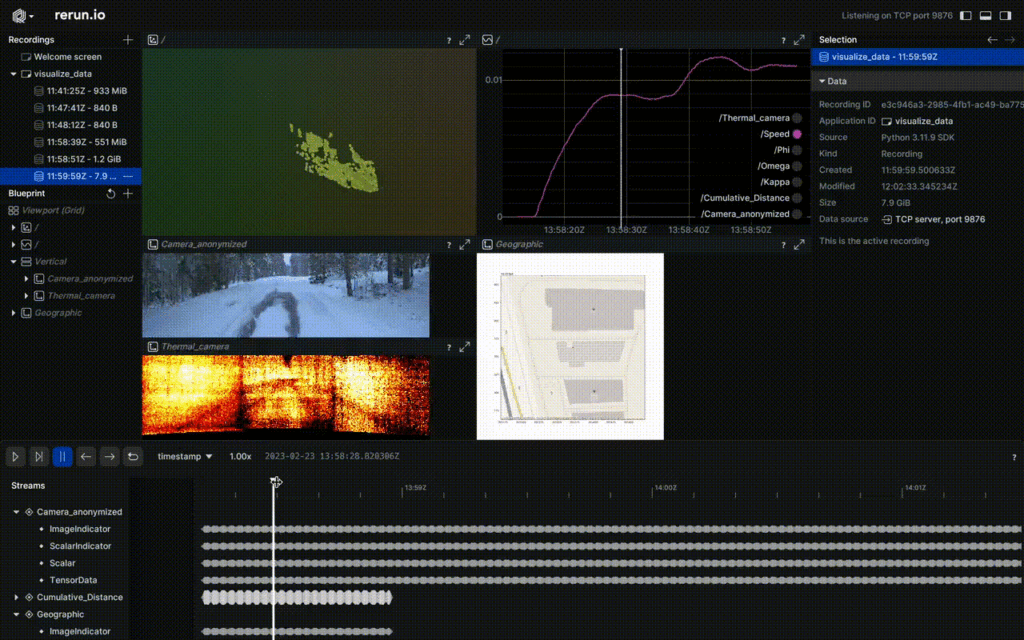
TO PLACE
Fused video from FGI, Finland.
Top RGB image; Center Thermal; and Bottom LiDAR distance.
And in the rerun tool.
List of Figures
Figure 1 – Data plays a central role in the ROADVIEW project. Above, a generic view of data of the data processing stages in chronological order (bottom first). 9
Figure 2 – The ROADVIEW reference architecture (source D2.3) 11
Figure 3 – Two visible light cameras used in the ROADVIEW project 14
Figure 4 – Two RADAR modules used in the ROADVIEW project 15
Figure 5 – Two LiDAR modules used in the ROADVIEW project 15
Figure 6 – An IMU unit 16
Figure 7 – Example of FGIs Urban 3 data sources fused, Video link (5fps). 24
Figure 8 – Blurriness obtained by taking the variation of the Laplacian of the 3000 images in the FGi’s dataset. Image sizes are scaled to HD. Higher values are less blurry. 25
Figure 9 – Refence Dataset of measured weather characteristics, THI D3.2, WP3 27
Figure 10 – nuScenes example (https://github.com/nutonomy/nuscenes-devkit) 30
Figure 11 – nuScenes example (https://github.com/nutonomy/nuscenes-devkit) 31
Figure 12 – Benchmarking Robustness of 3D Object Detection to Common Corruptions in Autonomous Driving 32
Figure 13 – Machine-generated scenes from WP2 33
List of Tables
Table 1 – Simple summary of sensors in autonomous driving (source: An Overview of Autonomous Vehicles Sensors and Their Vulnerability to Weather Conditions. Sensor [28]) 13
Table 2 – Image quality assessment with open-source repos 18
Table 3 – Specific Data Readiness Levels for ROADVIEW. The light-yellow shaded cells indicate Domain specific data issues whilst the light blue cells data agnostic processing. 20
Table 4 – Data formats from FGI dataset 22
Table 5 – Road Weather, conditions & data fields in the FGI Dataset 23
Table 6 – Two autonomous driving datasets from FGI (https://www.maanmittauslaitos.fi/en/research) 23
Table 7 – Output characteristics using the FGI dataset above. 24
Table 8 – Sensor sizes and rates from the FGI dataset. 25
Table 9 – Dataset summaries from the NuScences paper, processing of standard datasets can be found in MMdetection3D. The paper assesses methods applied to popular available datasets [22]. 28
Table 10 – Open-source datasets for use in autonomous vehicles and our processing priority 29
Abbreviations
AD Automated Driving
CAV Connected Automated Vehicle
DDI Direct Data Injection
DRL Data Readiness Level
EC European Commission
EU European Union
GNSS Global Navigation Satellite System
HD High Definition
HD MAP Detailed and highly accurate digital representation of the real-world environment
HiL Hardware-in-the-Loop
IMU Inertial Measurement Unit
ML Machine Learning
MRM Minimum Risk Manoeuvre
ODD Operational Design Domain
OEM Original Equipment Manufacturer
OTA Over-the-Air
TRL Technology Readiness Level
ViL Vehicle-in-the-Loop